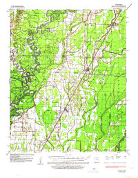
1935 Map of Alicia
USGS Topo · Published 1963About this map
The Black River dominates this mid-1930s landscape, its complex meanders and oxbows defining the borders between Lawrence, Jackson, and Independence counties. Before modern flood controls fully altered the basin, local life centered on the river's banks, as evidenced by the numerous landings like Paradise Ldg, Kenyon Ldg, and Eureka Ldg. This era shows a transition in transportation, where traditional river crossings like Whitelow Ferry and Lockheart Ferry existed alongside the Missouri Pacific and St Louis San Francisco RR lines.
Find a feature on this map
95 named features on this map. Tap any name to fly to it.
Don’t see what you’re looking for? This feature index may not catch every label — zoom into the map to look around manually.
Map Details
Editions of this 1935 Alicia Map
3 editions found
Other maps of this area

1932 · Strawberry
USGS Topo · 1:62,500

1932 · Walnut Ridge
USGS Topo · 1:62,500

1934 · Powhatan
USGS Topo · 1:62,500

1935 · Powhatan
USGS Topo · 1:62,500

1935 · Sedgwick
USGS Topo · 1:62,500

1935 · Alicia
USGS Topo · 1:62,500

1935 · Strawberry
USGS Topo · 1:62,500

1935 · Newport
USGS Topo · 1:62,500

1935 · Tuckerman
USGS Topo · 1:62,500

1935 · Walnut Ridge
USGS Topo · 1:62,500