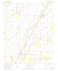
1980 Map of Alicia
USGS Topo · Published 1980About this map
Village Creek and its complex network of sloughs define the landscape of this Lawrence County region, where the Missouri Pacific railroad anchors the local infrastructure. The settlement of Alicia sits at a critical junction near the county line, while the surrounding plains are dotted with family and community landmarks such as Clover Bend and Hopewell Church. This 1980 edition reveals a geography heavily shaped by drainage and agriculture, evidenced by features like Marrow Bone Slough and White Oak Slough.
Find a feature on this map
26 named features on this map. Tap any name to fly to it.
Don’t see what you’re looking for? This feature index may not catch every label — zoom into the map to look around manually.
Map Details
Editions of this 1980 Alicia Map
This is the sole edition of this map. No revisions or reprints were ever made.
Other maps of this area

1932 · Walnut Ridge
USGS Topo · 1:62,500

1934 · Powhatan
USGS Topo · 1:62,500

1935 · Powhatan
USGS Topo · 1:62,500

1935 · Sedgwick
USGS Topo · 1:62,500

1935 · Alicia
USGS Topo · 1:62,500

1935 · Walnut Ridge
USGS Topo · 1:62,500

1953 · Memphis
USGS Topo · 1:250,000

1956 · Memphis
USGS Topo · 1:250,000

1957 · Poplar Bluff
USGS Topo · 1:250,000

1959 · Poplar Bluff
USGS Topo · 1:250,000