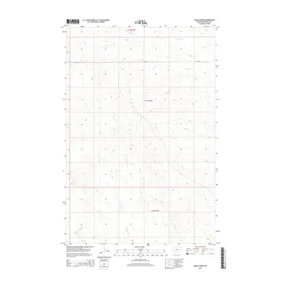
2014 Map of Alkali Creek
USGS Topo · Published 2014About this map
Alkali Cr and its many tributaries carve through this portion of Rosebud County, defining a landscape shaped by intermittent watercourses and high plains topography. The map illustrates a sparse, ranch-oriented region organized by the Public Land Survey System, with boundaries for t12n r43e, t11n r43e, and t10n r43e marking the vast sections of Montana's open country. Transport is focused on Road 203, which serves as a primary east-west artery through the northern reaches of the quadrangle. Researchers can trace the dendritic drainage patterns of Lone Tree Cr, Hay Cr, and the northern forks of Sunday Creek, which together reveal the natural hydrology that dictates land use in this semi-arid environment. The detailed contouring provides insight into the subtle elevation shifts between the creek beds and the surrounding ridges.
Find a feature on this map
10 named features on this map. Tap any name to fly to it.
Don’t see what you’re looking for? This feature index may not catch every label — zoom into the map to look around manually.
Map Details
Editions of this 2014 Alkali Creek Map
This is the sole edition of this map. No revisions or reprints were ever made.
Other maps of this area

1954 · Forsyth
USGS Topo · 1:250,000

1957 · Forsyth
USGS Topo · 1:250,000

1958 · Forsyth
USGS Topo · 1:250,000

1965 · Rock Springs School
USGS Topo · 1:24,000

1965 · Clear Water Reservoir
USGS Topo · 1:24,000
1965 · Red Buttes
USGS Topo · 1:24,000

1969 · Van Burton Creek
USGS Topo · 1:24,000

1969 · Wild Horse Pass SE
USGS Topo · 1:24,000

1969 · Wild Horse Pass
USGS Topo · 1:24,000
1969 · Alkali Creek
USGS Topo · 1:24,000