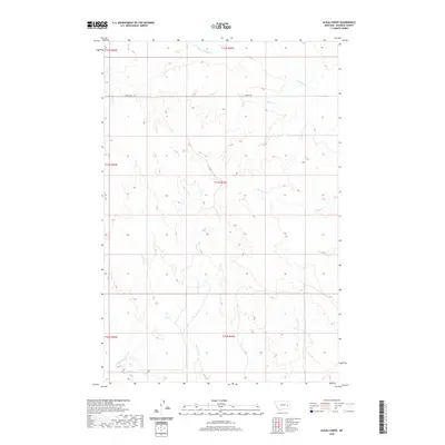
2020 Map of Alkali Creek
USGS Topo · Published 2020About this map
Alkali Creek and Lone Tree Creek drain this section of Rosebud County, where the high plains of eastern Montana are defined by a network of intermittent watercourses. The landscape is marked by the complex drainage systems of the West Fork North Sunday Creek and North Sunday Creek, which carve through the terrain between the surveyed township lines of T11N and T12N. S Angela Rd provides the primary corridor through this open country, connecting isolated points across the vast public land survey sections. The map preserves the specific hydrography and property boundaries of this ranching region, including the courses of Hay Creek and South Sunday Creek as they appeared at the start of the 2020s.
Find a feature on this map
13 named features on this map. Tap any name to fly to it.
Don’t see what you’re looking for? This feature index may not catch every label — zoom into the map to look around manually.
Map Details
Editions of this 2020 Alkali Creek Map
This is the sole edition of this map. No revisions or reprints were ever made.
Other maps of this area

1954 · Forsyth
USGS Topo · 1:250,000

1957 · Forsyth
USGS Topo · 1:250,000

1958 · Forsyth
USGS Topo · 1:250,000

1965 · Rock Springs School
USGS Topo · 1:24,000

1965 · Clear Water Reservoir
USGS Topo · 1:24,000
1965 · Red Buttes
USGS Topo · 1:24,000

1969 · Van Burton Creek
USGS Topo · 1:24,000

1969 · Wild Horse Pass SE
USGS Topo · 1:24,000

1969 · Wild Horse Pass
USGS Topo · 1:24,000
1969 · Alkali Creek
USGS Topo · 1:24,000