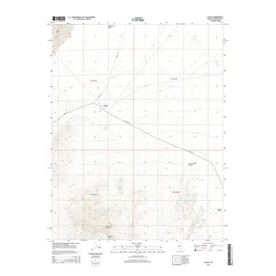
2014 Map of Alkali
USGS Topo · Published 2014About this map
Alkali Hot Spring and the small settlement of Alkali serve as central points in this arid landscape within the Montezuma Valley. The map illustrates a stark transition from the low-lying Alkali Lake in the northwest to the elevated terrain of the Montezuma Range in the south, which includes the prominent Flattop Mtn. Transportation through this corner of the Ralston Desert is defined by the long stretches of Alkali Rd and Powerline Rd, which cut across the basin. The topographical detail reveals the complex drainage of the area, notably through Indian Springs Canyon and the dry course of Big Wash. This survey provides a clear view of the relationship between the area's scarce water resources and the infrastructure established to navigate the high desert environment of Esmeralda County.
Find a feature on this map
15 named features on this map. Tap any name to fly to it.
Don’t see what you’re looking for? This feature index may not catch every label — zoom into the map to look around manually.
Map Details
Editions of this 2014 Alkali Map
This is the sole edition of this map. No revisions or reprints were ever made.
Other maps of this area

1908 · Lida
USGS Topo · 1:250,000

1913 · Lida
USGS Topo · 1:250,000

1945 · Goldfield
USGS Topo · 1:125,000

1952 · Mud Lake
USGS Topo · 1:62,500

1952 · Goldfield
USGS Topo · 1:62,500

1954 · Goldfield
USGS Topo · 1:250,000

1955 · Goldfield
USGS Topo · 1:250,000

1958 · Goldfield
USGS Topo · 1:250,000

1962 · Goldfield
USGS Topo · 1:250,000
1970 · Klondike
USGS Topo · 1:24,000