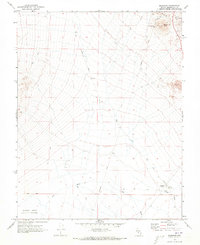
1970 Map of Klondike
USGS Topo · Published 1973About this map
The Klondike (Site) represents a focused point of historical interest in this arid Esmeralda County landscape, situated near a junction of transport and utility lines. Industrial activity is concentrated at the Tonopah Hasbrouck Mine and nearby Gravel Pit operations at the foot of Hasbrouck Peak. The map records a transition in transit, showing an Old Railroad Grade that once served the region alongside modern infrastructure like a Powerline and various Jeep Trails. To the south, the terrain descends toward the Alkali Lake Alkali Flat, a significant depression where the Big Wash terminates. This 1970 survey captures the infrastructure of the Nevada desert, from the Klondike Well (Dry) and its adjacent Water Tank to the critical survey benchmarks that define the township and range system near the Base Line.
Find a feature on this map
22 named features on this map. Tap any name to fly to it.
Don’t see what you’re looking for? This feature index may not catch every label — zoom into the map to look around manually.
Map Details
Editions of this 1970 Klondike Map
2 editions found
Other maps of this area

1907 · Tonopah
USGS Topo · 1:250,000

1908 · Lida
USGS Topo · 1:250,000

1908 · Tonopah
USGS Topo · 1:250,000

1913 · Lida
USGS Topo · 1:250,000

1945 · Goldfield
USGS Topo · 1:125,000

1952 · Mud Lake
USGS Topo · 1:62,500

1954 · Goldfield
USGS Topo · 1:250,000

1955 · Goldfield
USGS Topo · 1:250,000

1956 · Tonopah
USGS Topo · 1:250,000

1958 · Goldfield
USGS Topo · 1:250,000