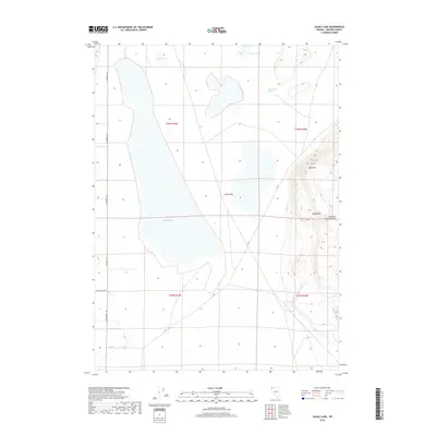
2018 Map of Alkali Lake
USGS Topo · Published 2018About this map
Alkali Lake dominates this Great Basin landscape, situated within the expansive Long Valley of Washoe County. This modern survey illustrates a remote corner of northern Nevada where water sources like Hills Warm Spring and Warm Springs were historically critical for travel and ranching. The terrain rises sharply to the east into the Painted Point Range, featuring distinct landmarks such as Big Point and the Little Basin. Primitive and secondary routes, including Ft Bidwell Rd and Smith Ranch Rd, trace the edges of the valley floor, connecting the scattered hydrographic features like Berrey Brook and Dry Lake. The map provides a precise look at the township and range grid system used for land management in this arid territory.
Find a feature on this map
16 named features on this map. Tap any name to fly to it.
Don’t see what you’re looking for? This feature index may not catch every label — zoom into the map to look around manually.
Map Details
Editions of this 2018 Alkali Lake Map
This is the sole edition of this map. No revisions or reprints were ever made.
Other maps of this area

1889 · Long Valley
USGS Topo · 1:250,000

1954 · Vya
USGS Topo · 1:250,000

1958 · Vya
USGS Topo · 1:250,000

1962 · Vya
USGS Topo · 1:250,000

1966 · Massacre Lake NW
USGS Topo · 1:24,000

1966 · Vya
USGS Topo · 1:24,000
1966 · Mosquito Valley
USGS Topo · 1:24,000
1966 · Calcutta Lake
USGS Topo · 1:24,000
1966 · Carter Reservoir
USGS Topo · 1:24,000

1966 · Alkali Lake
USGS Topo · 1:24,000