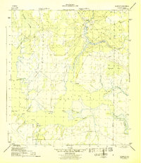
1945 Map of Allanton
USGS Topo · Published 1945About this map
Allanton and Farmdale sit at the edge of a complex network of wetlands and tidal inlets along East Bay during the mid-1940s. The landscape is defined by its transition from the piney woods and swamps of the interior to the salt marshes and bayous of the coast. A key feature of the region's transport and geography is the Intracoastal Waterway, which cuts through the eastern portion of the map near the confluence of Wetappo Creek. The settlement pattern follows the few established paths like Allanton Road, connecting small coastal points like Baker Pt and Lathrop Pt. Numerous named water bodies, including California Bayou, Eagle Nest Bayou, and Sandy Creek, illustrate the watery labyrinth of the California Swamp before modern development altered this stretch of the Florida Panhandle.
Find a feature on this map
30 named features on this map. Tap any name to fly to it.
Don’t see what you’re looking for? This feature index may not catch every label — zoom into the map to look around manually.
Map Details
Editions of this 1945 Allanton Map
3 editions found
Other maps of this area

1943 · Overstreet
USGS Topo · 1:31,680

1943 · Crooked Island
USGS Topo · 1:31,680

1944 · Beacon Hill
USGS Topo · 1:31,680

1944 · Long Point
USGS Topo · 1:31,680

1945 · Allanton
USGS Topo · 1:31,680

1945 · North Of Allanton
USGS Topo · 1:31,680

1945 · Wetappo Creek
USGS Topo · 1:31,680

1945 · Tenmile Swamp
USGS Topo · 1:31,680
1945 · Parker
USGS Topo · 1:31,680

1947 · Allanton
USGS Topo · 1:25,000