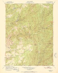
1951 Map of Alleghany
USGS Topo · Published 1951About this map
Alleghany serves as the focal point of this mountainous Sierra Nevada landscape, surrounded by a dense network of quartz and placer gold claims. The concentration of mining activity is particularly high along the Pliocene Ridge and the drainages of Kanaka Creek, where the famous Sixteen To One Mine and the Gold Crown Mine operated. This area reflects a mid-century period when many primary operations were transitioning to inactive status, yet the physical infrastructure of the era remains clearly documented, from the Lookout Cherry Hill to various ranch sites like Hagerty Ranch.
Find a feature on this map
107 named features on this map. Tap any name to fly to it.
Don’t see what you’re looking for? This feature index may not catch every label — zoom into the map to look around manually.
Map Details
Editions of this 1951 Alleghany Map
This is the sole edition of this map. No revisions or reprints were ever made.
Other maps of this area

1891 · Downieville
USGS Topo · 1:125,000

1891 · Colfax
USGS Topo · 1:125,000

1892 · Colfax
USGS Topo · 1:125,000

1893 · Downieville
USGS Topo · 1:125,000

1894 · Colfax
USGS Topo · 1:125,000

1895 · Downieville
USGS Topo · 1:125,000

1896 · Downieville
USGS Topo · 1:125,000

1897 · Downieville
USGS Topo · 1:125,000

1898 · Colfax
USGS Topo · 1:125,000

1900 · Colfax
USGS Topo · 1:125,000