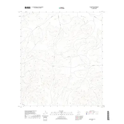
2019 Map of Allen Ranch
USGS Topo · Published 2019About this map
Allen Ranch serves as a primary waypoint in this remote section of Terrell County, situated at the confluence of several local ranch roads including Allen Rd and Hardgrave Rd. The landscape is dominated by complex topographical features, most notably the deep cut of Big Canyon which runs through the northern reaches of the sheet. In the southwest, the broad corridor of Downie Draw shapes the local drainage and terrain. The network of winding unpaved routes, such as Walker Rd and Running W Rd, illustrates the isolation of these West Texas ranchlands. This map captures the intersection of high-desert drainage patterns and the sparse infrastructure necessary to maintain large-scale ranching operations in a rugged environmental context.
Find a feature on this map
9 named features on this map. Tap any name to fly to it.
Don’t see what you’re looking for? This feature index may not catch every label — zoom into the map to look around manually.
Map Details
Editions of this 2019 Allen Ranch Map
This is the sole edition of this map. No revisions or reprints were ever made.
Other maps of this area

1928 · Sanderson
USGS Topo · 1:125,000

1954 · Fort Stockton
USGS Topo · 1:250,000

1958 · Fort Stockton
USGS Topo · 1:250,000

1969 · Circle Dot Ranch
USGS Topo · 1:24,000

1969 · Big Canyon Ranch
USGS Topo · 1:24,000

1969 · Continental Ranch
USGS Topo · 1:24,000

1969 · Circle Dot Ranch NE
USGS Topo · 1:24,000

1969 · Dryden NE
USGS Topo · 1:24,000

1969 · Dryden NW
USGS Topo · 1:24,000
1969 · Sanderson NE
USGS Topo · 1:24,000