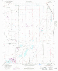
1954 Map of Allensworth
USGS Topo · Published 1971About this map
Allensworth stands as a prominent focal point along the Atchison Topeka and Santa Fe railroad line in this mid-century survey of the San Joaquin Valley. The landscape reveals a complex network of water management and industrial activity, characterized by an extensive system of levee structures and the Alpaugh Irrigation District Canal. The map captures the industrial footprint of the Trico Gas Field, with numerous Gas Wells dotting the sections north of the Tulare Co Kern Co boundary line.
Find a feature on this map
26 named features on this map. Tap any name to fly to it.
Don’t see what you’re looking for? This feature index may not catch every label — zoom into the map to look around manually.
Map Details
Editions of this 1954 Allensworth Map
3 editions found
Other maps of this area

1914 · Lost Hills
USGS Topo · 1:125,000

1929 · Alpaugh
USGS Topo · 1:31,680

1929 · Hacienda Ranch
USGS Topo · 1:31,680

1929 · Pixley
USGS Topo · 1:31,680

1929 · West Alpaugh
USGS Topo · 1:31,680

1929 · Stone
USGS Topo · 1:31,680

1929 · Allensworth
USGS Topo · 1:31,680

1930 · Hamlin School
USGS Topo · 1:31,680

1930 · Pond
USGS Topo · 1:31,680

1930 · Miramonte Ranch
USGS Topo · 1:31,680