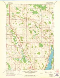
1959 Map of Allenton
USGS Topo · Published 1973About this map
Allenton serves as a central hub in this mid-century portrait of Washington County, where the Rock River and various spring-fed streams define the agricultural landscape. The map captures a transition period for rural communities like Kohlsville and Aurora, documenting the distribution of parochial and public life through sites such as St Johns Sch and Sacred Heart Cem. To the east, the shoreline of Cedar Lake is detailed with distinctive landmarks including Point Lookout and Linden Point, illustrating the area's recreational geography. Numerous Gravel Pits scattered throughout the townships of Wayne, Addison, and Barton suggest the importance of local material extraction for road building during this era. Small crossroads settlements like St Anthony and the presence of the Hahn Sky Ranch Landing Field reflect the varied transport and aviation infrastructure supporting these Wisconsin farming communities before late-century suburban expansion.
Find a feature on this map
39 named features on this map. Tap any name to fly to it.
Don’t see what you’re looking for? This feature index may not catch every label — zoom into the map to look around manually.
Map Details
Editions of this 1959 Allenton Map
2 editions found
Other maps of this area

1904 · West Bend
USGS Topo · 1:62,500

1904 · Hartford
USGS Topo · 1:62,500

1955 · Campbellsport
USGS Topo · 1:62,500

1955 · Kewaskum
USGS Topo · 1:62,500

1957 · Madison
USGS Topo · 1:250,000

1959 · West Bend
USGS Topo · 1:62,500

1959 · Hartford
USGS Topo · 1:62,500

1959 · Nenno
USGS Topo · 1:24,000

1959 · Allenton
USGS Topo · 1:24,000
1959 · Jackson
USGS Topo · 1:24,000