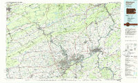
1984 Map of Allentown
USGS Topo · Published 1985About this map
The Lehigh River corridor serves as the industrial and geographic spine of this mid-1980s landscape, connecting the anthracite-region history of Hazleton and Jim Thorpe to the urban manufacturing centers of Allentown, Bethlehem, and Easton. This era marks a significant point in the transition of the Lehigh Valley, where traditional industrial infrastructure like the Conrail lines operates alongside major academic institutions such as Lehigh University and Lafayette College. To the north and west, the terrain is defined by the massive ridges of Kittatinny Mountain and Blue Mountain, which frame the Delaware Water Gap. The map captures a well-developed network of reservoirs, including Wild Creek Reservoir and Beltzville Lake, supporting a region that balances dense valley settlements like Catasauqua and Northampton with the expansive State Game Lands No 141 and the Delaware Water Gap National Recreation Area along the New Jersey border.
Find a feature on this map
74 named features on this map. Tap any name to fly to it.
Don’t see what you’re looking for? This feature index may not catch every label — zoom into the map to look around manually.
Map Details
Editions of this 1984 Allentown Map
3 editions found
Other maps of this area

1888 · Hackettstown
USGS Topo · 1:62,500

1888 · Quakertown
USGS Topo · 1:62,500

1889 · Hazleton
USGS Topo · 1:62,500

1889 · Pottsville
USGS Topo · 1:62,500

1890 · Easton
USGS Topo · 1:62,500

1890 · High Bridge
USGS Topo · 1:62,500

1890 · Lambertville
USGS Topo · 1:62,500

1890 · Doylestown
USGS Topo · 1:62,500

1890 · Quakertown
USGS Topo · 1:62,500

1891 · Easton
USGS Topo · 1:62,500