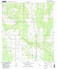
1994 Map of Allentown
USGS Topo · Published 1998About this map
The rural community of Allentown serves as a central hub in this Santa Rosa County landscape, where agriculture and petroleum extraction intersect. The terrain is defined by the drainage networks of West Fork Juniper Creek and Big Coldwater Creek, with several Oil Wells scattered across the northwestern sections, particularly near Blackjack Creek. These industrial sites appear alongside established local institutions like the Allentown Sch and a series of rural houses of worship, including Walling Ch, Harmony Ch, and Pleasant Grove Ch. In the southern reaches, a Radio Tower and Landing Strip indicate modern infrastructure, while numerous Claypits show the continued extraction of natural resources. The presence of the Chavers Cem and several unnamed cemeteries provides valuable location data for genealogists tracing local families during the mid-to-late 1990s.
Find a feature on this map
28 named features on this map. Tap any name to fly to it.
Don’t see what you’re looking for? This feature index may not catch every label — zoom into the map to look around manually.
Map Details
Editions of this 1994 Allentown Map
This is the sole edition of this map. No revisions or reprints were ever made.
Other maps of this area

1920 · Milton
USGS Topo · 1:62,500

1934 · Harold
USGS Topo · 1:62,500

1937 · Harold
USGS Topo · 1:62,500

1938 · Harold
USGS Topo · 1:62,500

1941 · Milton
USGS Topo · 1:62,500

1943 · Milton
USGS Topo · 1:62,500

1943 · Jay
USGS Topo · 1:62,500

1948 · Munson
USGS Topo · 1:62,500

1950 · Munson
USGS Topo · 1:62,500

1957 · Pensacola
USGS Topo · 1:250,000