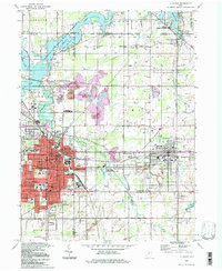
1994 Map of Alliance
USGS Topo · Published 1997About this map
The Mahoning River corridors and the industrial landscape of eastern Ohio anchor this survey, centered on the city of Alliance and the neighboring manufacturing town of Sebring. The map details a significant urban-industrial transition, featuring the extensive grounds of Mt Union College and the hub of Conrail lines that shaped the regional economy. Beyond the city limits, the terrain shifts toward resource extraction and recreation, evidenced by Strip Mines north of the city and the vast Berlin Lake State Wildlife Area along the northern boundary. Genealogists will find a wealth of local landmarks, from the Old German Cem in the northwest to various neighborhood schools like Rockhill Sch and State Street Sch, providing a clear view of the social and educational infrastructure of these Mahoning Valley communities.
Find a feature on this map
68 named features on this map. Tap any name to fly to it.
Don’t see what you’re looking for? This feature index may not catch every label — zoom into the map to look around manually.
Map Details
Editions of this 1994 Alliance Map
This is the sole edition of this map. No revisions or reprints were ever made.
Other maps of this area

1906 · Ravenna
USGS Topo · 1:62,500

1908 · Warren
USGS Topo · 1:62,500

1908 · Ravenna
USGS Topo · 1:62,500

1909 · Alliance
USGS Topo · 1:62,500

1909 · Lisbon
USGS Topo · 1:62,500

1950 · Cleveland
USGS Topo · 1:250,000

1951 · Canton
USGS Topo · 1:250,000

1952 · Lake Milton
USGS Topo · 1:24,000

1952 · Alliance
USGS Topo · 1:24,000

1952 · Damascus
USGS Topo · 1:24,000