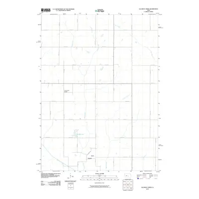
2010 Map of Alloway Creek
USGS Topo · Published 2010About this map
The northern reaches of Marshall County are defined by the winding course of Rock Creek, which meanders through a landscape shaped by rural agricultural development. This 2010 survey by the U.S. Geological Survey illustrates the enduring section-line grid that organizes the terrain into a network of farmsteads and open fields. The creek itself provides the primary natural relief in an otherwise structured landscape of straight roads and irrigation patterns, serving as a critical drainage feature for the surrounding prairie. While the area is largely characterized by active land use, the map serves as a contemporary record of the natural hydrology that has influenced local settlement patterns since the early days of Iowa's statehood.
Find a feature on this map
1 named feature on this map. Tap any name to fly to it.
Don’t see what you’re looking for? This feature index may not catch every label — zoom into the map to look around manually.
Map Details
Editions of this 2010 Alloway Creek Map
This is the sole edition of this map. No revisions or reprints were ever made.
Other maps of this area

1954 · Des Moines
USGS Topo · 1:250,000

1956 · Des Moines
USGS Topo · 1:250,000

1957 · Des Moines
USGS Topo · 1:250,000

1965 · Newton
USGS Topo · 1:24,000

1969 · Des Moines
USGS Topo · 1:250,000
1975 · Melbourne
USGS Topo · 1:24,000

1975 · Baxter SE
USGS Topo · 1:24,000

1980 · Newburg
USGS Topo · 1:24,000
1980 · Gilman
USGS Topo · 1:24,000
1980 · Laurel
USGS Topo · 1:24,000
Featured Places
- Jefferson Township, IA
- Malaka Township, IA
- Newton Township, IA
- Rock Creek Township, IA
- Hickory Grove Township, IA