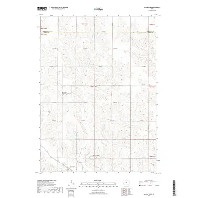
2018 Map of Alloway Creek
USGS Topo · Published 2018About this map
The North Skunk River defines the southwestern corner of this Iowa landscape, where the borders of Marshall and Jasper Counties meet. This terrain is carved by an intricate network of waterways, including the winding Alloway Creek, Potatoe Creek, and Rock Creek, which drain the agricultural uplands. Evidence of early community settlement is preserved in the location of the German Society Methodist Cemetery and the Rushville Cemetery, providing significant anchor points for genealogical research in these rural townships. The map illustrates a strictly gridded system of section roads like N 83rd Ave E and 340th St, typical of the Midwest's rural organization. Near the center, Ken Wolfe Lake serves as a distinct landmark amidst the rolling drainage basins of W Burr Oak Creek and Coon Creek.
Find a feature on this map
39 named features on this map. Tap any name to fly to it.
Don’t see what you’re looking for? This feature index may not catch every label — zoom into the map to look around manually.
Map Details
Editions of this 2018 Alloway Creek Map
This is the sole edition of this map. No revisions or reprints were ever made.
Other maps of this area

1954 · Des Moines
USGS Topo · 1:250,000

1956 · Des Moines
USGS Topo · 1:250,000

1957 · Des Moines
USGS Topo · 1:250,000

1965 · Newton
USGS Topo · 1:24,000

1969 · Des Moines
USGS Topo · 1:250,000
1975 · Melbourne
USGS Topo · 1:24,000

1975 · Baxter SE
USGS Topo · 1:24,000

1980 · Newburg
USGS Topo · 1:24,000
1980 · Gilman
USGS Topo · 1:24,000
1980 · Laurel
USGS Topo · 1:24,000
Featured Places
- Jefferson Township, IA
- Malaka Township, IA
- Newton Township, IA
- Rock Creek Township, IA
- Hickory Grove Township, IA