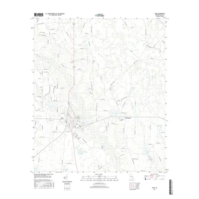
2017 Map of Alma
USGS Topo · Published 2017About this map
Alma serves as the primary municipal hub in this south Georgia landscape, characterized by a grid of residential streets and central community landmarks like Rose Hill Cem. East of the city, the smaller settlement of Rockingham sits along the highway, supported by the nearby Rockingham Cem. The surrounding terrain is defined by a dense network of blackwater streams and wetlands, including Hurricane Cr and Tenmile Cr, which feed into numerous named water bodies such as Lake Lure and the expansive Aldridge and Eason Lake. Numerous family-named cemeteries, such as Johnsons Cem and Holton Cem, are scattered across the rural acreage, providing vital touchpoints for genealogical research. The road network reflects a mix of modern transit and older rural routes like Bennett Still Hwy, bordering the low-lying basins of Bear Br and Rigdon Br.
Find a feature on this map
130 named features on this map. Tap any name to fly to it.
Don’t see what you’re looking for? This feature index may not catch every label — zoom into the map to look around manually.
Map Details
Editions of this 2017 Alma Map
This is the sole edition of this map. No revisions or reprints were ever made.
Other maps of this area

1953 · Waycross
USGS Topo · 1:250,000

1958 · Waycross
USGS Topo · 1:250,000

1971 · Nicholls NE
USGS Topo · 1:24,000

1971 · Coffee
USGS Topo · 1:24,000

1971 · Alma NW
USGS Topo · 1:24,000

1971 · Beach
USGS Topo · 1:24,000

1971 · Alma
USGS Topo · 1:24,000

1971 · Sessoms
USGS Topo · 1:24,000

1971 · Mershon
USGS Topo · 1:24,000
1971 · Alma NE
USGS Topo · 1:24,000