
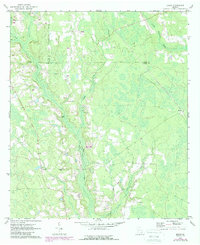
1971 Map of Beach
USGS Topo · Published 1974About this map
Hurricane Creek and its many tributaries, including Brushy Creek and Hog Creek, dominate this rural landscape at the intersection of Coffee, Bacon, and Ware Counties. The 1971 field check captures a period when the Seaboard Coast Line railroad still cut a diagonal path through the timbered wetlands and small clearings. Small, localized settlements like Bickley and Beach serve as anchors for the surrounding agricultural community, which is dotted with several family-named burial grounds including Cole Cem, Bagley Cem, and Moore Cem. This survey provides a distinct look at the land-use patterns of the era, where extractive industry is visible through several labeled sandpits near the center of the sheet. For those interested in the social geography of south Georgia, the map includes significant local landmarks such as Salem Ch, Grace Chapel, and a prominent Lookout Tower positioned near the western edge of the quadrangle.
Find a feature on this map
21 named features on this map. Tap any name to fly to it.
Don’t see what you’re looking for? This feature index may not catch every label — zoom into the map to look around manually.
Map Details
Editions of this 1971 Beach Map
2 editions found
Other maps of this area

1953 · Waycross
USGS Topo · 1:250,000

1958 · Waycross
USGS Topo · 1:250,000

1971 · Dixie Union
USGS Topo · 1:24,000

1971 · Nicholls
USGS Topo · 1:24,000

1971 · Wilsonville
USGS Topo · 1:24,000

1971 · Axson
USGS Topo · 1:24,000

1971 · Alma
USGS Topo · 1:24,000

1971 · Sessoms
USGS Topo · 1:24,000

1971 · Talmo
USGS Topo · 1:24,000
1971 · Crawley
USGS Topo · 1:24,000