
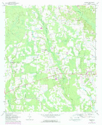
1971 Map of Sessoms
USGS Topo · Published 1974About this map
The Seaboard Coast Line railroad forms a primary corridor through this South Georgia landscape, connecting the small settlements of Sessoms and Guysie as it runs toward Alma. This early 1970s survey captures a rural environment defined by a dense network of country churches and family cemeteries, indicating a deeply rooted community structure. Landmarks like Elam Ch, Wesley Chapel, and Mount Pleasant Ch are scattered across the terrain, often located near watercourses like Little Hurricane Creek and Hog Creek.
Find a feature on this map
28 named features on this map. Tap any name to fly to it.
Don’t see what you’re looking for? This feature index may not catch every label — zoom into the map to look around manually.
Map Details
Editions of this 1971 Sessoms Map
2 editions found
Other maps of this area

1953 · Waycross
USGS Topo · 1:250,000

1958 · Waycross
USGS Topo · 1:250,000

1971 · Nicholls NE
USGS Topo · 1:24,000

1971 · Nicholls
USGS Topo · 1:24,000

1971 · Wilsonville
USGS Topo · 1:24,000

1971 · Alma NW
USGS Topo · 1:24,000

1971 · Beach
USGS Topo · 1:24,000

1971 · Alma
USGS Topo · 1:24,000

1971 · Denton
USGS Topo · 1:24,000
1971 · Crawley
USGS Topo · 1:24,000