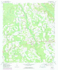
1971 Map of Sessoms
USGS Topo · Published 1988About this map
The low-lying landscape of Bacon Co and Coffee Co is defined by the winding course of Hurricane Creek and its tributary, Little Hurricane Creek. This 1971 record of the area shows a rural infrastructure supported by numerous country churches and family burial grounds, including Elam Ch and the Stewart Cem. The settlement of Sessoms sits at the heart of this agricultural region, while to the east, the western edge of Alma appears with the Bacon County Airport and a prominent Radio Tower. Large sections of the terrain are marked by wetlands and a significant Pipeline corridor cutting across the southern half of the quadrangle. The 1983 photo-revisions, shown in purple, reveal modernization around Guysie and the airport, reflecting the gradual growth of infrastructure within the traditional timber and farm country of south Georgia.
Find a feature on this map
29 named features on this map. Tap any name to fly to it.
Don’t see what you’re looking for? This feature index may not catch every label — zoom into the map to look around manually.
Map Details
Editions of this 1971 Sessoms Map
2 editions found
Other maps of this area

1953 · Waycross
USGS Topo · 1:250,000

1958 · Waycross
USGS Topo · 1:250,000

1971 · Nicholls NE
USGS Topo · 1:24,000

1971 · Nicholls
USGS Topo · 1:24,000

1971 · Wilsonville
USGS Topo · 1:24,000

1971 · Alma NW
USGS Topo · 1:24,000

1971 · Beach
USGS Topo · 1:24,000

1971 · Alma
USGS Topo · 1:24,000

1971 · Sessoms
USGS Topo · 1:24,000

1971 · Denton
USGS Topo · 1:24,000