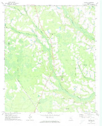
1971 Map of Crawley
USGS Topo · Published 1974About this map
Crawley and Bolen serve as the primary focal points of this 1970s landscape, positioned along the Seaboard Coast Line railroad. The map reveals a rural community structure defined by its numerous faith-based centers, including Elizabeth Chapel, Adventist Ch, and Corinth Ch. The terrain is deeply influenced by the intricate drainage systems of Hurricane Creek and Little Hurricane Creek, which create vast marshy areas and wetlands interspersed with timber and farmland. For genealogists, the inclusion of family-named landmarks like Sweat Cem and Lee Chapel Cem provides specific points for tracing local family roots. The transition between Bacon Co, Ware Co, and Pierce Co is marked by irregular boundaries following the natural flow of watercourses like Big Branch and Mill Branch.
Find a feature on this map
22 named features on this map. Tap any name to fly to it.
Don’t see what you’re looking for? This feature index may not catch every label — zoom into the map to look around manually.
Map Details
Editions of this 1971 Crawley Map
2 editions found
Other maps of this area

1953 · Waycross
USGS Topo · 1:250,000

1958 · Waycross
USGS Topo · 1:250,000

1971 · Dixie Union
USGS Topo · 1:24,000

1971 · Coffee
USGS Topo · 1:24,000

1971 · Beach
USGS Topo · 1:24,000

1971 · Alma
USGS Topo · 1:24,000

1971 · Sessoms
USGS Topo · 1:24,000

1971 · Talmo
USGS Topo · 1:24,000

1971 · Blackshear West
USGS Topo · 1:24,000

1971 · Mershon
USGS Topo · 1:24,000