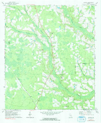
1971 Map of Crawley
USGS Topo · Published 1991About this map
Crawley and the nearby siding of Bolen anchor this Southeast Georgia landscape at the junction of three counties. The Seaboard Coast Line railroad cuts a diagonal path through the southwestern corner, reflecting the historic importance of rail transport for the local timber and agricultural economy. The terrain is defined by a dense network of blackwater drainages, including Hurricane Creek and Little Hurricane Creek, which feed into the extensive swampy lowlands that characterize the region.
Find a feature on this map
21 named features on this map. Tap any name to fly to it.
Don’t see what you’re looking for? This feature index may not catch every label — zoom into the map to look around manually.
Map Details
Editions of this 1971 Crawley Map
2 editions found
Other maps of this area

1953 · Waycross
USGS Topo · 1:250,000

1958 · Waycross
USGS Topo · 1:250,000

1971 · Dixie Union
USGS Topo · 1:24,000

1971 · Coffee
USGS Topo · 1:24,000

1971 · Beach
USGS Topo · 1:24,000

1971 · Alma
USGS Topo · 1:24,000

1971 · Sessoms
USGS Topo · 1:24,000

1971 · Talmo
USGS Topo · 1:24,000

1971 · Blackshear West
USGS Topo · 1:24,000

1971 · Mershon
USGS Topo · 1:24,000