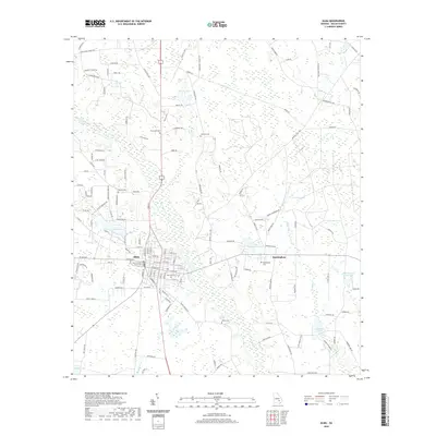
2020 Map of Alma
USGS Topo · Published 2020About this map
Alma serves as the focal point of this coastal plain survey, situated at the junction of several regional routes and housing the Bacon County Courthouse. The town’s grid is flanked by natural drainages like Hurricane Cr to the north and Bear Br to the south. To the east, the smaller settlement of Rockingham sits near the headwaters of Tenmile Cr. The landscape is notably dense with family and community burial grounds, including Rose Hill Cem, Rockingham Cem, and Taylors Cem, which offer significant value for genealogical research in this part of Georgia. Multiple water bodies like Lake Lure and several namesake ponds, such as Johnson Lake and Mullis Lake, punctuate the low-lying terrain, illustrating the hydrologic character of the region before the modern era of extensive land modification.
Find a feature on this map
123 named features on this map. Tap any name to fly to it.
Don’t see what you’re looking for? This feature index may not catch every label — zoom into the map to look around manually.
Map Details
Editions of this 2020 Alma Map
This is the sole edition of this map. No revisions or reprints were ever made.
Other maps of this area

1953 · Waycross
USGS Topo · 1:250,000

1958 · Waycross
USGS Topo · 1:250,000

1971 · Nicholls NE
USGS Topo · 1:24,000

1971 · Coffee
USGS Topo · 1:24,000

1971 · Alma NW
USGS Topo · 1:24,000

1971 · Beach
USGS Topo · 1:24,000

1971 · Alma
USGS Topo · 1:24,000

1971 · Sessoms
USGS Topo · 1:24,000

1971 · Mershon
USGS Topo · 1:24,000
1971 · Alma NE
USGS Topo · 1:24,000