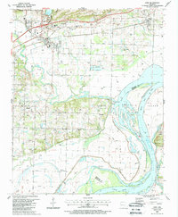
1987 Map of Alma
USGS Topo · Published 1988About this map
Alma serves as the focal point of this late 1980s Crawford County survey, illustrating the convergence of mid-century infrastructure and natural river geography. The Arkansas River and Ozark Lake dominate the southern landscape, separated from agricultural land and settlements like Yoestown and New Town by a significant Road on Levee. The region's spiritual and social history is deeply rooted in its rural corners, evidenced by numerous small burial grounds and congregations such as Twelve Corner Cem, Beal Cem, and Harmony Ch.
Find a feature on this map
48 named features on this map. Tap any name to fly to it.
Don’t see what you’re looking for? This feature index may not catch every label — zoom into the map to look around manually.
Map Details
Editions of this 1987 Alma Map
This is the sole edition of this map. No revisions or reprints were ever made.
Other maps of this area

1879 · Fort Smith
USGS Topo · 1:62,500

1887 · Van Buren
USGS Topo · 1:62,500

1890 · Fort Smith
USGS Topo · 1:125,000

1898 · Winslow #4
USGS Topo · 1:62,500

1898 · Winslow #3
USGS Topo · 1:62,500

1898 · Winslow
USGS Topo · 1:125,000

1901 · Winslow
USGS Topo · 1:125,000

1906 · Lavaca
USGS Topo · 1:62,500

1943 · Fort Smith
USGS Topo · 1:125,000

1946 · Fort Smith
USGS Topo · 1:250,000