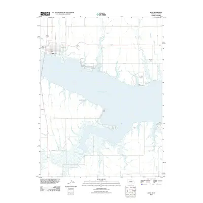
2011 Map of Alma
USGS Topo · Published 2011About this map
Alma serves as the focal point of this Republican River valley landscape, situated along the northern shores of the expansive Harlan County Lake. The 2011 survey reveals a complex shoreline defined by prominent landmarks such as Pheasant Point, Sindt Point, and White Cat Point, which reach into the reservoir. This artificial lake has fundamentally reshaped the local geography, creating numerous inlets like Methodist Cove, North Cove, and Bone Cove. The map documents a blend of municipal infrastructure and recreational development, including the Alma Municipal Airport and the specialized Harlan County Lake Seaplane Base. To the east, the Republican City Cemetery stands as a significant site for genealogical research, while the surrounding terrain is carved by natural drainages including Cook Creek, Tipover Creek, and Mill Creek which feed into the central basin from the north, and Prairie Dog Creek approaching from the southwest.
Find a feature on this map
43 named features on this map. Tap any name to fly to it.
Don’t see what you’re looking for? This feature index may not catch every label — zoom into the map to look around manually.
Map Details
Editions of this 2011 Alma Map
This is the sole edition of this map. No revisions or reprints were ever made.
Other maps of this area

1893 · Phillipsburg
USGS Topo · 1:125,000

1896 · Holdrege
USGS Topo · 1:125,000

1955 · Grand Island
USGS Topo · 1:250,000

1955 · Beloit
USGS Topo · 1:250,000

1957 · Grand Island
USGS Topo · 1:250,000

1958 · Grand Island
USGS Topo · 1:250,000

1959 · Beloit
USGS Topo · 1:250,000

1968 · Woodruff
USGS Topo · 1:24,000

1973 · Stuttgart NE
USGS Topo · 1:24,000
1973 · Kensington NW
USGS Topo · 1:24,000