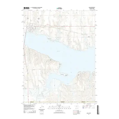
2014 Map of Alma
USGS Topo · Published 2014About this map
Harlan County Lake dominates this 2014 landscape, marking a massive aquatic border between the settled northern shore and the rugged south bank. The town of Alma sits at the reservoir's northwestern edge, defined by a grid of streets including W Main St and Everett Ave that transition into the Alma Municipal Airport. This modern survey illustrates how the water has transformed the geography, creating a series of prominent landforms like Pheasant Point, Sindt Point, and White Cat Point.
Find a feature on this map
46 named features on this map. Tap any name to fly to it.
Don’t see what you’re looking for? This feature index may not catch every label — zoom into the map to look around manually.
Map Details
Editions of this 2014 Alma Map
This is the sole edition of this map. No revisions or reprints were ever made.
Other maps of this area

1893 · Phillipsburg
USGS Topo · 1:125,000

1896 · Holdrege
USGS Topo · 1:125,000

1955 · Grand Island
USGS Topo · 1:250,000

1955 · Beloit
USGS Topo · 1:250,000

1957 · Grand Island
USGS Topo · 1:250,000

1958 · Grand Island
USGS Topo · 1:250,000

1959 · Beloit
USGS Topo · 1:250,000

1968 · Woodruff
USGS Topo · 1:24,000

1973 · Stuttgart NE
USGS Topo · 1:24,000
1973 · Kensington NW
USGS Topo · 1:24,000