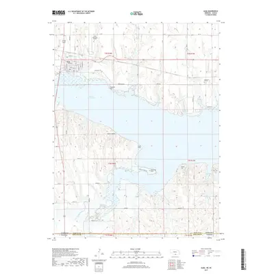
2017 Map of Alma
USGS Topo · Published 2017About this map
The settlement of Alma serves as the primary hub in this southern Nebraska landscape, situated along the northern shores of Harlan County Lake. The lake dominates the central portion of the map, featuring a complex shoreline with numerous named points and coves including Methodist Cove, North Cove, and the distinctive White Cat Point. This 2017 survey illustrates the modern configuration of the area's recreational and agricultural lands, extending from the Alma Municipal Airport down to the Nebraska-Kansas state line.
Find a feature on this map
55 named features on this map. Tap any name to fly to it.
Don’t see what you’re looking for? This feature index may not catch every label — zoom into the map to look around manually.
Map Details
Editions of this 2017 Alma Map
This is the sole edition of this map. No revisions or reprints were ever made.
Other maps of this area

1893 · Phillipsburg
USGS Topo · 1:125,000

1896 · Holdrege
USGS Topo · 1:125,000

1955 · Grand Island
USGS Topo · 1:250,000

1955 · Beloit
USGS Topo · 1:250,000

1957 · Grand Island
USGS Topo · 1:250,000

1958 · Grand Island
USGS Topo · 1:250,000

1959 · Beloit
USGS Topo · 1:250,000

1968 · Woodruff
USGS Topo · 1:24,000

1973 · Stuttgart NE
USGS Topo · 1:24,000
1973 · Kensington NW
USGS Topo · 1:24,000