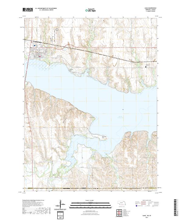
2021 Map of Alma
USGS Topo · Published 2021About this map
Alma serves as the focal point of this Harlan County region, situated along the northern shores of the expansive Harlan County Lake. The town's grid is anchored by the Harlan County Courthouse and extends toward the Alma Municipal Airport. The landscape is defined by the significant indentation of the reservoir into the surrounding plains, creating numerous prominent landforms such as Pheasant Point, Sindt Point, and White Cat Point. These points, along with sheltered waters like Methodist Cove and North Cove, illustrate the transformation of the local topography by the lake. To the south, the terrain becomes more broken, featuring Coyote Canyon and Indian Hill. This area also marks a clear political boundary where the state line divides Harlan Co and Nebraska Kansas, showing the transition from Nebraska's township system into Kansas territory.
Find a feature on this map
41 named features on this map. Tap any name to fly to it.
Don’t see what you’re looking for? This feature index may not catch every label — zoom into the map to look around manually.
Map Details
Editions of this 2021 Alma Map
This is the sole edition of this map. No revisions or reprints were ever made.
Other maps of this area

1893 · Phillipsburg
USGS Topo · 1:125,000

1896 · Holdrege
USGS Topo · 1:125,000

1955 · Grand Island
USGS Topo · 1:250,000

1955 · Beloit
USGS Topo · 1:250,000

1957 · Grand Island
USGS Topo · 1:250,000

1958 · Grand Island
USGS Topo · 1:250,000

1959 · Beloit
USGS Topo · 1:250,000

1968 · Woodruff
USGS Topo · 1:24,000

1973 · Stuttgart NE
USGS Topo · 1:24,000
1973 · Kensington NW
USGS Topo · 1:24,000