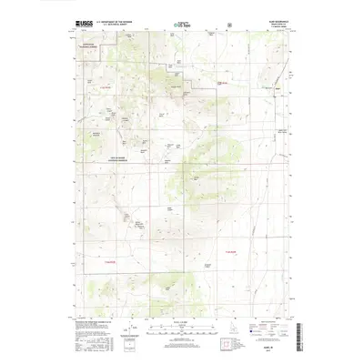
2017 Map of Almo
USGS Topo · Published 2017About this map
Almo serves as the central hub for this portion of the Upper Raft River Valley, where the transition from high-desert valley floor to the dramatic formations of the City of Rocks National Reserve is meticulously documented. The terrain is characterized by massive granitic monoliths with evocative names like Elephant Rock, Steinfells Dome, and the Twin Sisters, which rise sharply from the landscape. To the north, the boundary of the Sawtooth National Forest encompasses Graham Peak, while the western edge of the map follows the high ridges of the Albion Mountains. This 2017 survey details a landscape where historical geography and geological features are inextricably linked, showing the proximity of the Raft River to the complex systems of canyons such as Heath Canyon and Emigrant Canyon. The placement of Register Rock and Pinnacle Pass highlights the topographical constraints that have shaped travel through this southern Idaho corridor for generations.
Find a feature on this map
56 named features on this map. Tap any name to fly to it.
Don’t see what you’re looking for? This feature index may not catch every label — zoom into the map to look around manually.
Map Details
Editions of this 2017 Almo Map
This is the sole edition of this map. No revisions or reprints were ever made.
Other maps of this area

1954 · Pocatello
USGS Topo · 1:250,000

1954 · Brigham City
USGS Topo · 1:250,000

1958 · Pocatello
USGS Topo · 1:250,000

1958 · Brigham City
USGS Topo · 1:250,000

1959 · Cotton Thomas Basin
USGS Topo · 1:62,500

1959 · Yost
USGS Topo · 1:62,500

1962 · Brigham City
USGS Topo · 1:250,000

1968 · Almo
USGS Topo · 1:24,000

1968 · Cache Peak
USGS Topo · 1:24,000

1968 · Basin
USGS Topo · 1:24,000