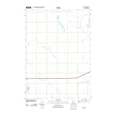
2010 Map of Alpha
USGS Topo · Published 2010About this map
The small settlement of Alpha anchors this Jackson County landscape, characterized by the winding path of the East Fork Des Moines River and a highly developed network of agricultural drainage systems. The town is concentrated around the Alpha Post Office, situated in the southwestern portion of the quadrangle. Surrounding the village, the terrain is defined by a grid of rural roads and water management features like Judicial Ditch Number Thirtytwo and County Ditch Number One, which speak to the area's intensive agricultural history. In the northern reaches, Watkins Lake and the meandering Elm Creek provide natural landmarks amidst the rectilinear township and range layout. This 2010 survey illustrates the persistence of small-town prairie life and the engineering required to manage the wetlands of southern Minnesota, where water moves through both natural riverbeds and named judicial ditches.
Find a feature on this map
30 named features on this map. Tap any name to fly to it.
Don’t see what you’re looking for? This feature index may not catch every label — zoom into the map to look around manually.
Map Details
Editions of this 2010 Alpha Map
This is the sole edition of this map. No revisions or reprints were ever made.
Other maps of this area

1954 · Fairmont
USGS Topo · 1:250,000

1958 · Fairmont
USGS Topo · 1:250,000

1970 · Jackson NW
USGS Topo · 1:24,000

1970 · Ceylon
USGS Topo · 1:24,000

1970 · Jackson
USGS Topo · 1:24,000

1970 · Trimont
USGS Topo · 1:24,000

1970 · Mountain Lake SE
USGS Topo · 1:24,000
1970 · Bergen
USGS Topo · 1:24,000

1970 · Dunnell
USGS Topo · 1:24,000

1970 · Sherburn
USGS Topo · 1:24,000