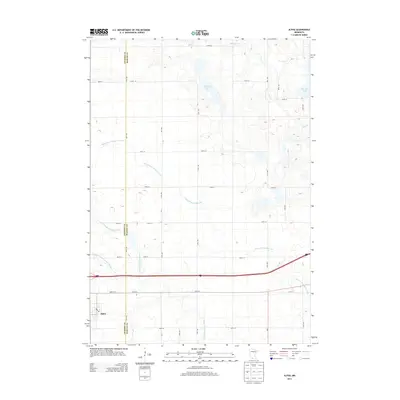
2013 Map of Alpha
USGS Topo · Published 2013About this map
The small settlement of Alpha anchors the southwestern corner of this survey, situated just north of the E Fork Des Moines River on the border between Jackson Co and Martin Co. The landscape is defined by the heavy modification of the prairie drainage system, evidenced by a network of engineered waterways such as Judicial Ditch Number Fifteen and County Ditch Number One. These canals crisscross the agricultural grid, redirecting water away from natural depressions and toward the river or the larger basins of Watkins Lake and Big Twin Lake. A rigid grid of rural roads, including 180th St and 50th Ave, partitions the land into precise sections, reflecting the enduring township-and-range layout of southern Minnesota. Small pockets of natural hydrology remain visible along the meandering course of Elm Cr as it flows toward the northeastern edge of the quadrangle.
Find a feature on this map
32 named features on this map. Tap any name to fly to it.
Don’t see what you’re looking for? This feature index may not catch every label — zoom into the map to look around manually.
Map Details
Editions of this 2013 Alpha Map
This is the sole edition of this map. No revisions or reprints were ever made.
Other maps of this area

1954 · Fairmont
USGS Topo · 1:250,000

1958 · Fairmont
USGS Topo · 1:250,000

1970 · Jackson NW
USGS Topo · 1:24,000

1970 · Ceylon
USGS Topo · 1:24,000

1970 · Jackson
USGS Topo · 1:24,000

1970 · Trimont
USGS Topo · 1:24,000

1970 · Mountain Lake SE
USGS Topo · 1:24,000
1970 · Bergen
USGS Topo · 1:24,000

1970 · Dunnell
USGS Topo · 1:24,000

1970 · Sherburn
USGS Topo · 1:24,000