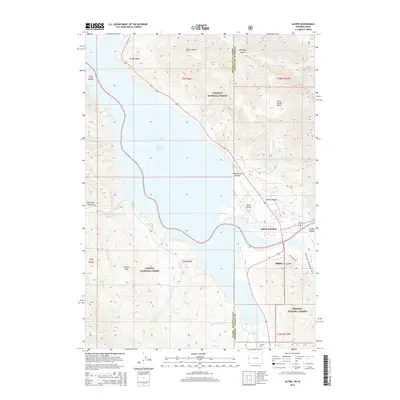
2015 Map of Alpine
USGS Topo · Published 2015About this map
Alpine and Alpine Junction sit at the strategic intersection of the Salt River and the Snake River's entrance to Palisades Reservoir, marking a vital nexus of water, transport, and mountain geography. This area is uniquely positioned where three major wilderness tracts converge, including the Targhee National Forest, Caribou National Forest, and Bridger National Forest. The landscape is defined by deep drainage systems like Little Box Canyon and Smith Canyon, while Bitters Peak overlooks the western mountain slopes. The presence of the Alpine Airport and the Grey's River Rd indicates the town's role as a modern gateway to the backcountry. To the east, the Grey's River Snowmobile Trail and the towering walls of the Grand Canyon highlight the region's transition from a valley floor to some of the state's most dramatic high-altitude terrain along the Idaho and Wyoming border.
Find a feature on this map
36 named features on this map. Tap any name to fly to it.
Don’t see what you’re looking for? This feature index may not catch every label — zoom into the map to look around manually.
Map Details
Editions of this 2015 Alpine Map
This is the sole edition of this map. No revisions or reprints were ever made.
Other maps of this area

1931 · Jackson
USGS Topo · 1:125,000

1932 · Irwin
USGS Topo · 1:96,000

1935 · Irwin
USGS Topo · 1:125,000

1935 · Jackson
USGS Topo · 1:125,000

1955 · Driggs
USGS Topo · 1:250,000

1958 · Driggs
USGS Topo · 1:250,000

1962 · Driggs
USGS Topo · 1:250,000

1963 · Observation Peak
USGS Topo · 1:24,000

1963 · Ferry Peak
USGS Topo · 1:24,000
1965 · Stewart Peak
USGS Topo · 1:24,000