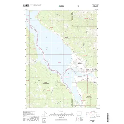
2018 Map of Alpine
USGS Topo · Published 2018About this map
Alpine sits at a major crossroads of high-altitude canyons and hydrology along the border between Wyoming and Idaho. This 2018 survey captures the intricate shoreline of the Palisades Reservoir, where the Salt River and other drainages converge. The settlement pattern is concentrated around Alpine Junction and the Alpine Airport, serving as a gateway to the surrounding wilderness. The map documents the overlap of three major managed landscapes: the Targhee National Forest, Caribou National Forest, and Bridger National Forest. Notable peaks like Bitters Peak and carved features such as Grand Canyon and Grand Valley define the verticality of the terrain. For those tracing the evolution of regional recreation and infrastructure, labels like Alpine Hot Springs and Nelson Ln provide specific points of reference for local development near the state line.
Find a feature on this map
43 named features on this map. Tap any name to fly to it.
Don’t see what you’re looking for? This feature index may not catch every label — zoom into the map to look around manually.
Map Details
Editions of this 2018 Alpine Map
This is the sole edition of this map. No revisions or reprints were ever made.
Other maps of this area

1931 · Jackson
USGS Topo · 1:125,000

1932 · Irwin
USGS Topo · 1:96,000

1935 · Irwin
USGS Topo · 1:125,000

1935 · Jackson
USGS Topo · 1:125,000

1955 · Driggs
USGS Topo · 1:250,000

1958 · Driggs
USGS Topo · 1:250,000

1962 · Driggs
USGS Topo · 1:250,000

1963 · Observation Peak
USGS Topo · 1:24,000

1963 · Ferry Peak
USGS Topo · 1:24,000
1965 · Stewart Peak
USGS Topo · 1:24,000