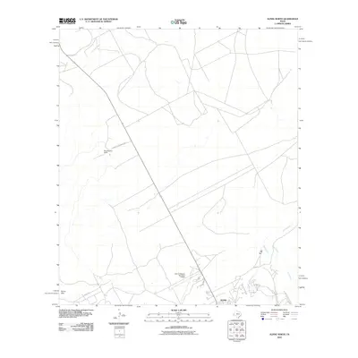
2010 Map of Alpine North
USGS Topo · Published 2010About this map
Alpine's northern outskirts and the high desert plains of Brewster County define this 2010 landscape. The geography is marked by intermittent watercourses like Musquiz Creek in the northwest and Paisano Creek to the south, reflecting the arid nature of the Trans-Pecos region. Transportation and ranching history converge at the Merriweather Ranch, accessed via Merriweather Ranch Rd, illustrating the legacy of large landholdings in West Texas.
Find a feature on this map
12 named features on this map. Tap any name to fly to it.
Don’t see what you’re looking for? This feature index may not catch every label — zoom into the map to look around manually.
Map Details
Editions of this 2010 Alpine North Map
This is the sole edition of this map. No revisions or reprints were ever made.
Other maps of this area

1894 · Fort Davis
USGS Topo · 1:125,000

1895 · Alpine
USGS Topo · 1:125,000

1897 · Fort Davis
USGS Topo · 1:125,000

1954 · Fort Stockton
USGS Topo · 1:250,000

1958 · Fort Stockton
USGS Topo · 1:250,000

1972 · Bird Mountain
USGS Topo · 1:24,000
1972 · Fort Davis SE
USGS Topo · 1:24,000

1972 · Alpine North
USGS Topo · 1:24,000

1972 · Paisano
USGS Topo · 1:24,000

1972 · Mitre Peak
USGS Topo · 1:24,000