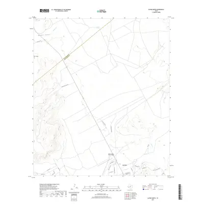
2019 Map of Alpine North
USGS Topo · Published 2019About this map
Alpine occupies the southeastern corner of this West Texas survey, where the town limits meet the northern foothills of the Glass Mountains. The landscape is defined by wide desert basins and drainage networks including Musquiz Creek and Paisano Creek, which flow through the high plains toward the Rio Grande watershed. To the north and west, the terrain rises into the jagged breaks of Musquiz Canyon and Box Canyon, reflecting the transition from town settlement to large-scale ranching territory.
Find a feature on this map
28 named features on this map. Tap any name to fly to it.
Don’t see what you’re looking for? This feature index may not catch every label — zoom into the map to look around manually.
Map Details
Editions of this 2019 Alpine North Map
This is the sole edition of this map. No revisions or reprints were ever made.
Other maps of this area

1894 · Fort Davis
USGS Topo · 1:125,000

1895 · Alpine
USGS Topo · 1:125,000

1897 · Fort Davis
USGS Topo · 1:125,000

1954 · Fort Stockton
USGS Topo · 1:250,000

1958 · Fort Stockton
USGS Topo · 1:250,000

1972 · Bird Mountain
USGS Topo · 1:24,000
1972 · Fort Davis SE
USGS Topo · 1:24,000

1972 · Alpine North
USGS Topo · 1:24,000

1972 · Paisano
USGS Topo · 1:24,000

1972 · Mitre Peak
USGS Topo · 1:24,000