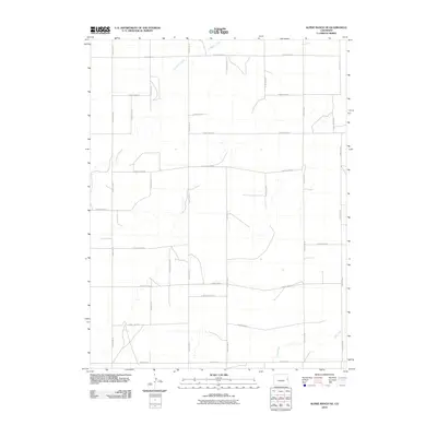
2010 Map of Alpine Ranch NE
USGS Topo · Published 2010About this map
Landsman Creek winds through the northern reaches of this high plains landscape in Kit Carson County, carving subtle drainage patterns across a strictly organized rural grid. The map reveals the rigid spatial geometry of the American West, where property and passage are defined by an exhaustive network of section-line roads such as County Road R and County Rd-32. In the southern portion of the quadrangle, Sand Creek introduces further topographical variation to an otherwise regular agricultural layout. This 2010 survey illustrates the persistence of the homestead-era township and range system, showing how modern county infrastructure like County Road H remains tethered to the original late-nineteenth-century land surveys. The lack of concentrated settlements highlights the enduringly open, pastoral nature of the region.
Find a feature on this map
23 named features on this map. Tap any name to fly to it.
Don’t see what you’re looking for? This feature index may not catch every label — zoom into the map to look around manually.
Map Details
Editions of this 2010 Alpine Ranch NE Map
This is the sole edition of this map. No revisions or reprints were ever made.
Other maps of this area

1954 · Limon
USGS Topo · 1:250,000

1957 · Limon
USGS Topo · 1:250,000

1958 · Limon
USGS Topo · 1:250,000

1969 · Alpine Ranch NE
USGS Topo · 1:24,000

1969 · Bethune
USGS Topo · 1:24,000

1969 · Burlington 3 NW
USGS Topo · 1:24,000

1969 · Stratton
USGS Topo · 1:24,000

1969 · Alpine Ranch
USGS Topo · 1:24,000
1969 · Burlington 3 SW
USGS Topo · 1:24,000
1970 · South of Bethune
USGS Topo · 1:24,000