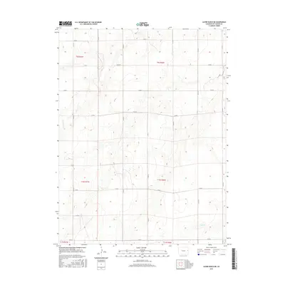
2016 Map of Alpine Ranch NE
USGS Topo · Published 2016About this map
Landsman Cr meanders through this portion of the High Plains, carving a subtle drainage pattern across the agricultural grid of Kit Carson County. The landscape is defined by the Public Land Survey System, with township boundaries like t9s r46w and t10s r47w organizing the territory into precise sections. This network of section lines is physically manifested by an extensive system of county roads, including Co Rd R and Co Rd G, which trace the cardinal directions across the plains. In the southern reaches, Sand Cr crosses the terrain, marking another of the region's intermittent watercourses that have historically dictated the placement of ranches and homesteads. The map illustrates a rural environment where land use is dictated by the availability of water and the rigorous geometry of the section grid.
Find a feature on this map
24 named features on this map. Tap any name to fly to it.
Don’t see what you’re looking for? This feature index may not catch every label — zoom into the map to look around manually.
Map Details
Editions of this 2016 Alpine Ranch NE Map
This is the sole edition of this map. No revisions or reprints were ever made.
Other maps of this area

1954 · Limon
USGS Topo · 1:250,000

1957 · Limon
USGS Topo · 1:250,000

1958 · Limon
USGS Topo · 1:250,000

1969 · Alpine Ranch NE
USGS Topo · 1:24,000

1969 · Bethune
USGS Topo · 1:24,000

1969 · Burlington 3 NW
USGS Topo · 1:24,000

1969 · Stratton
USGS Topo · 1:24,000

1969 · Alpine Ranch
USGS Topo · 1:24,000
1969 · Burlington 3 SW
USGS Topo · 1:24,000
1970 · South of Bethune
USGS Topo · 1:24,000