
1970 Map of Alsen SE
USGS Topo · Published 1972About this map
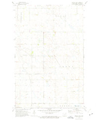
Glacial prairie potholes and depressional wetlands dominate this landscape on the border of Cavalier and Ramsey Counties. In the northeastern corner, the Billings Lake National Wildlife Refuge provides a protected sanctuary amidst the section-line roads and agricultural fields. This 1970 field-checked survey captures the rural infrastructure of townships like Storlie, Loma, and Billings, where local civic life centered around the Townhall and the Loma Cem. The Burlington Northern railroad cuts through the southern portion of the map, serving as the primary commercial artery for the surrounding plains. The terrain is marked by numerous small water bodies and several Gravel Pit operations, reflecting the area's post-glacial geology and its influence on local industry and settlement patterns.
Find a feature on this map
11 named features on this map. Tap any name to fly to it.
Don’t see what you’re looking for? This feature index may not catch every label — zoom into the map to look around manually.
Map Details
Editions of this 1970 Alsen SE Map
This is the sole edition of this map. No revisions or reprints were ever made.
Other maps of this area

1953 · Devils Lake
USGS Topo · 1:250,000

1956 · Devils Lake
USGS Topo · 1:250,000

1970 · Alsen
USGS Topo · 1:24,000

1970 · Loma
USGS Topo · 1:24,000

1970 · Hampden
USGS Topo · 1:24,000

1972 · Derrick NW
USGS Topo · 1:24,000

1972 · Derrick
USGS Topo · 1:24,000

1972 · Edmore
USGS Topo · 1:24,000

1972 · Billings Lake
USGS Topo · 1:24,000
1972 · Nekoma NW
USGS Topo · 1:24,000