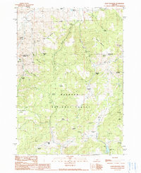
1990 Map of Alsup Mountain
USGS Topo · Published 1990About this map
Malheur National Forest spans the heart of this landscape, where the South Fork John Day River carves through the high country of eastern Oregon. The 1990 survey documents a transition in land use, marking several former homestead and activity hubs as archaeological or historical locations, including the Carey Ranch (Site) and Brown Ranch (Site). These sites, along with the Buttes Ranch (Site) and Hunter Cabin (Site), offer specific points of interest for genealogists and local historians tracing the ranching families that once operated in these uplands.
Find a feature on this map
52 named features on this map. Tap any name to fly to it.
Don’t see what you’re looking for? This feature index may not catch every label — zoom into the map to look around manually.
Map Details
Editions of this 1990 Alsup Mountain Map
This is the sole edition of this map. No revisions or reprints were ever made.
Other maps of this area

1955 · Burns
USGS Topo · 1:250,000

1955 · Canyon City
USGS Topo · 1:250,000

1958 · Burns
USGS Topo · 1:250,000

1959 · Burns
USGS Topo · 1:250,000

1959 · Canyon City
USGS Topo · 1:250,000

1959 · West Myrtle Butte
USGS Topo · 1:62,500

1959 · Sawtooth Creek
USGS Topo · 1:62,500

1961 · Logdell
USGS Topo · 1:62,500

1961 · Izee
USGS Topo · 1:62,500

1981 · Dayville
USGS Topo · 1:100,000