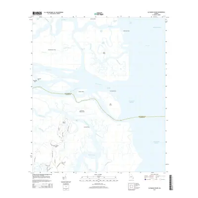
2014 Map of Altamaha Sound
USGS Topo · Published 2014About this map
Saint Simons Island and its northern reaches define the southern half of this coastal survey, where the Hampton River and Altamaha Sound meet the Atlantic. The landscape is a complex network of barrier islands and tidal marshes, featuring major landforms like Wolf Island, Rockdedundy Island, and Little Saint Simons Island. At Cannons Point and Butler Point, the map documents the modern residential street grid including Stillwater Dr and Cannons Point Rd, providing a clear look at how human settlement interacts with the shifting waterways of the Georgia coast. The Intracoastal Waterway cuts through Dolbow Island, serving as a vital artery between the mainland and the sea. The boundary between Mcintosh Co and Glynn Co winds through the South Altamaha River, illustrating the political divisions of these estuarine environments.
Find a feature on this map
54 named features on this map. Tap any name to fly to it.
Don’t see what you’re looking for? This feature index may not catch every label — zoom into the map to look around manually.
Map Details
Editions of this 2014 Altamaha Sound Map
This is the sole edition of this map. No revisions or reprints were ever made.
Other maps of this area

1920 · Cabretta Island
USGS Topo · 1:62,500

1921 · Darien
USGS Topo · 1:62,500

1944 · Cabretta Island
USGS Topo · 1:62,500

1945 · Brunswick
USGS Topo · 1:62,500

1946 · Brunswick
USGS Topo · 1:250,000

1948 · Brunswick
USGS Topo · 1:250,000

1954 · Altamaha Sound
USGS Topo · 1:24,000
1954 · Doboy Sound
USGS Topo · 1:24,000
1954 · Ridgeville
USGS Topo · 1:24,000

1954 · Cabretta Inlet
USGS Topo · 1:24,000