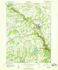
1944 Map of Altamont
USGS Topo · Published 1959About this map
The village of Altamont sits at the base of the Helderberg Mountains, where the Delaware and Hudson railroad cuts through the terrain. This wartime-era mapping illustrates a landscape of high ridges and steep escarpments, notably around the Thacher State Park and the distinctive Indian Ladder cliffside. Educational and religious landmarks are prominent, including the Lasalette Seminary and the village Union Sch, while a network of numbered schoolhouses like School No 12 and School No 13 serve the surrounding rural townships of Knox and Berne.
Find a feature on this map
47 named features on this map. Tap any name to fly to it.
Don’t see what you’re looking for? This feature index may not catch every label — zoom into the map to look around manually.
Map Details
Editions of this 1944 Altamont Map
4 editions found
Other maps of this area

1893 · Schenectady
USGS Topo · 1:62,500

1893 · Albany
USGS Topo · 1:62,500

1895 · Albany
USGS Topo · 1:62,500

1895 · Schenectady
USGS Topo · 1:62,500

1895 · Amsterdam
USGS Topo · 1:62,500

1898 · Schenectady
USGS Topo · 1:62,500

1898 · Albany
USGS Topo · 1:62,500

1900 · Berne
USGS Topo · 1:62,500

1903 · Berne
USGS Topo · 1:62,500

1927 · Albany
USGS Topo · 1:62,500