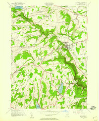
1944 Map of Altamont
USGS Topo · Published 1959About this map
The village of Altamont serves as the focal point of this mid-century topographic study, where the village's rail-dependent grid meets the steep escarpments of the Helderberg Mountains. The Delaware and Hudson railroad cuts diagonally across the landscape, connecting the village and its Fairgrounds to the rural townships of Guilderland and Knox. This era shows a community defined by its civic and religious institutions, such as the Union School and the La Salette Seminary. To the south, the dramatic transition from the valley floor to the plateau is marked by the cliffs of Indian Ladder and the sprawling acreage of Thacher State Park. Small rural schools like School No 2 and Settles Hill School are still distributed throughout the uplands, alongside local landmarks like Thompsons Lake and Warner Lake, reflecting a landscape that remained deeply tied to its natural geography and established township boundaries.
Find a feature on this map
57 named features on this map. Tap any name to fly to it.
Don’t see what you’re looking for? This feature index may not catch every label — zoom into the map to look around manually.
Map Details
Editions of this 1944 Altamont Map
4 editions found
Other maps of this area

1893 · Schenectady
USGS Topo · 1:62,500

1893 · Albany
USGS Topo · 1:62,500

1895 · Albany
USGS Topo · 1:62,500

1895 · Schenectady
USGS Topo · 1:62,500

1895 · Amsterdam
USGS Topo · 1:62,500

1898 · Schenectady
USGS Topo · 1:62,500

1898 · Albany
USGS Topo · 1:62,500

1900 · Berne
USGS Topo · 1:62,500

1903 · Berne
USGS Topo · 1:62,500

1927 · Albany
USGS Topo · 1:62,500