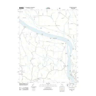
2012 Map of Altenburg
USGS Topo · Published 2012About this map
Wittenberg and Altenburg anchor the Missouri side of the Mississippi River in this 2012 survey, which highlights the deeply intertwined river geography of Perry and Jackson counties. The map captures a landscape defined by dramatic limestone features and fertile bottomlands, from the iconic Tower Rock rising out of the water to the heights of Fountain Bluff and Walker Hill across the channel. The area's settlement history is evident in the numerous religious and community landmarks, including Saint Pauls Lutheran Cem and Concordia Lutheran Cem, as well as small landings like Loimbach Landing and Brunkhorst Landing that once facilitated river commerce. Inland, the terrain is carved by the Brazeau Cr and Owl Cr, while the Illinois side features a complex network of drainage and levee systems protecting the Brazeau Bottoms. This edition provides a clear view of the modern road network, including Indian Ridge Rd and Neunert Rd, connecting rural settlements like Jacob and Neunert.
Find a feature on this map
102 named features on this map. Tap any name to fly to it.
Don’t see what you’re looking for? This feature index may not catch every label — zoom into the map to look around manually.
Map Details
Editions of this 2012 Altenburg Map
This is the sole edition of this map. No revisions or reprints were ever made.
Other maps of this area

1910 · Murphysboro
USGS Topo · 1:62,500

1916 · Campbell Hill
USGS Topo · 1:62,500

1918 · Altenburg
USGS Topo · 1:62,500

1918 · Campbell Hill
USGS Topo · 1:62,500

1924 · Alto Pass
USGS Topo · 1:62,500

1925 · Altenburg
USGS Topo · 1:62,500

1938 · Murphysboro
USGS Topo · 1:62,500

1947 · Alto Pass
USGS Topo · 1:62,500

1947 · Crosstown
USGS Topo · 1:24,000

1947 · Oak Ridge
USGS Topo · 1:24,000