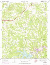
1968 Map of Alton
USGS Topo · Published 1979About this map
Turbeville and Alton anchor this landscape along the Virginia and North Carolina border, where the rural character of Halifax County is defined by a network of creeks and small family-named landmarks. The southern portion of the map is dominated by the sprawling waters of Hyco Lake and the After Bay Reservoir, reflecting mid-century water management along the Hyco River. A significant industrial corridor is traced by the Pipeline and the Norfolk and Western railroad, which cuts through the small settlement of Cunningham.
Find a feature on this map
36 named features on this map. Tap any name to fly to it.
Don’t see what you’re looking for? This feature index may not catch every label — zoom into the map to look around manually.
Map Details
Editions of this 1968 Alton Map
3 editions found
Other maps of this area

1943 · Roxboro
USGS Topo · 1:62,500

1952 · Milton
USGS Topo · 1:62,500

1953 · South Boston
USGS Topo · 1:62,500

1953 · Greensboro
USGS Topo · 1:250,000

1954 · Greensboro
USGS Topo · 1:250,000

1956 · Milton
USGS Topo · 1:62,500

1957 · South Boston
USGS Topo · 1:62,500

1962 · Greensboro
USGS Topo · 1:250,000

1966 · Greensboro
USGS Topo · 1:250,000

1968 · Leasburg
USGS Topo · 1:24,000