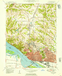
1948 Map of Alton
USGS Topo · Published 1954About this map
The Mississippi River defines the southwestern edge of this post-war landscape, where the bustling industrial hub of Alton gives way to upland institutions and rural townships. Educational landmarks figure prominently across the terrain, from Shurtleff College and the Western Military Academy in Upper Alton to the sprawling grounds of Monticello Seminary further north in Godfrey. The riverfront is dominated by transportation infrastructure, including the Lewis and Clark Toll Bridge and the extensive tracks of the Gulf Mobile and Ohio and Illinois Terminal railroads.
Find a feature on this map
60 named features on this map. Tap any name to fly to it.
Don’t see what you’re looking for? This feature index may not catch every label — zoom into the map to look around manually.
Map Details
Editions of this 1948 Alton Map
This is the sole edition of this map. No revisions or reprints were ever made.
Other maps of this area

1925 · Brighton
USGS Topo · 1:62,500

1927 · Alton
USGS Topo · 1:62,500

1927 · St. Charles
USGS Topo · 1:62,500

1928 · Brighton
USGS Topo · 1:62,500

1930 · Jerseyville
USGS Topo · 1:62,500

1933 · Jerseyville
USGS Topo · 1:62,500

1933 · Saint Charles
USGS Topo · 1:62,500

1934 · Alton
USGS Topo · 1:62,500

1935 · Florissant
USGS Topo · 1:24,000

1935 · Columbia Bottom
USGS Topo · 1:24,000