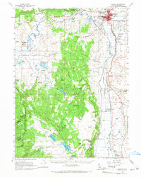
1961 Map of Alturas
USGS Topo · Published 1967About this map
Alturas serves as the focal point of this Modoc County survey, situated at the confluence of the Pit River and its South Fork Pit River. The town's infrastructure in the early 1960s is detailed, including the courthouse, Municipal Airport, and the Southern Pacific railroad line through Lakeview Junc. To the south, the Modoc National Wildlife Refuge encompasses a network of wetlands and weirs along the river's path. Historical depth is provided by the Infernal Caverns Battleground Memorial Marker and the nearby Infernal Caverns Ruins in the southern hills, commemorating conflict on the frontier. The landscape transitions from the agricultural Warm Springs Valley and its many reservoirs, like Graves Reservoir, to the timbered heights of the Modoc National Forest, where features such as Graven Ridge and Rocky Prairie define the high country.
Find a feature on this map
71 named features on this map. Tap any name to fly to it.
Don’t see what you’re looking for? This feature index may not catch every label — zoom into the map to look around manually.
Map Details
Editions of this 1961 Alturas Map
3 editions found
Other maps of this area

1886 · Alturas
USGS Topo · 1:250,000

1892 · Alturas
USGS Topo · 1:250,000

1954 · Alturas
USGS Topo · 1:250,000

1958 · Alturas
USGS Topo · 1:250,000

1961 · Canby
USGS Topo · 1:62,500

1961 · Alturas
USGS Topo · 1:62,500

1962 · Alturas
USGS Topo · 1:250,000

1962 · Davis Creek
USGS Topo · 1:62,500
1962 · Adin
USGS Topo · 1:62,500

1962 · Tule Mountain
USGS Topo · 1:24,000