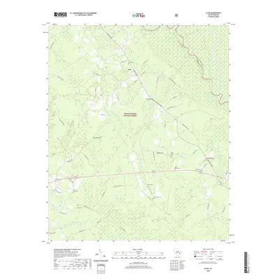
2020 Map of Alvin
USGS Topo · Published 2020About this map
Alvin sits at the northern edge of the Francis Marion National Forest, where the landscape is defined by the wetlands of the Santee River basin. This survey documents a rural environment where private timberlands and hunting grounds like the Walleye Hunt Club meet protected federal forest. The area is characterized by low-lying hydrologic features such as Bullhead Bay and Wedboo Bay, which feed into a network of creeks and swamps including Beaver Dam Swamp and Whiskinboo Creek. Historic crossing points are noted at Wedboo Bridge and Rogers Bridge, providing vital links across the river and its numerous branches. Genealogists will find a high concentration of burial sites throughout the township, including Edens Cemetery near the settlement and Macedonia Cemetery to the west, reflecting a deeply rooted local community within the Berkeley County and Williamsburg County borderlands.
Find a feature on this map
65 named features on this map. Tap any name to fly to it.
Don’t see what you’re looking for? This feature index may not catch every label — zoom into the map to look around manually.
Map Details
Editions of this 2020 Alvin Map
This is the sole edition of this map. No revisions or reprints were ever made.
Other maps of this area

1919 · Cordesville
USGS Topo · 1:48,000

1943 · Shulerville
USGS Topo · 1:24,000

1943 · Trio
USGS Topo · 1:24,000

1943 · Jamestown
USGS Topo · 1:24,000

1943 · Bonneau
USGS Topo · 1:62,500

1948 · Cordesville
USGS Topo · 1:24,000

1948 · Bethera
USGS Topo · 1:24,000
1949 · Cordesville
USGS Topo · 1:24,000

1949 · Georgetown
USGS Topo · 1:250,000
1950 · Bethera
USGS Topo · 1:24,000