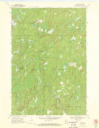
1970 Map of Alvin
USGS Topo · Published 1972About this map
Alvin serves as the small settlement hub within the sprawling Nicolet National Forest of Forest County during the early 1970s. The landscape is defined by a dense network of waterways, including the North Branch Pine River and the Popple River, alongside numerous glacial lakes like May Lake and Onimish Lake. For genealogists and local historians, Lakeview Cem stands just north of the village center, while several Gravel Pit operations near town suggest the importance of road maintenance and local material extraction.
Find a feature on this map
26 named features on this map. Tap any name to fly to it.
Don’t see what you’re looking for? This feature index may not catch every label — zoom into the map to look around manually.
Map Details
Editions of this 1970 Alvin Map
3 editions found
Other maps of this area

1898 · Iron River
USGS Topo · 1:62,500

1938 · Alvin
USGS Topo · 1:48,000

1939 · Long Lake
USGS Topo · 1:48,000

1944 · Iron River
USGS Topo · 1:24,000

1946 · Iron River
USGS Topo · 1:31,680

1946 · Alvin
USGS Topo · 1:48,000

1948 · Long Lake
USGS Topo · 1:48,000

1954 · Iron Mountain
USGS Topo · 1:250,000

1956 · Beechwood
USGS Topo · 1:62,500

1958 · Iron River
USGS Topo · 1:250,000