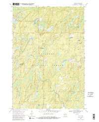
1970 Map of Alvin
USGS Topo · Published 1982About this map
The small unincorporated community of Alvin serves as the focal point for this 1970 field check of Forest County, surrounded by the heavily wooded terrain of the Nicolet National Forest. Water dominates the landscape, with the Pine River and Meadowbrook Creek winding through the southern reaches, while the northern sections are punctuated by locally named landmarks like Charlie Otto Spring and Zieler Spring. Genealogy interests are centered at Lakeview Cem near May Lake, a quiet site just west of the town center.
Find a feature on this map
23 named features on this map. Tap any name to fly to it.
Don’t see what you’re looking for? This feature index may not catch every label — zoom into the map to look around manually.
Map Details
Editions of this 1970 Alvin Map
3 editions found
Other maps of this area

1898 · Iron River
USGS Topo · 1:62,500

1938 · Alvin
USGS Topo · 1:48,000

1939 · Long Lake
USGS Topo · 1:48,000

1944 · Iron River
USGS Topo · 1:24,000

1946 · Iron River
USGS Topo · 1:31,680

1946 · Alvin
USGS Topo · 1:48,000

1948 · Long Lake
USGS Topo · 1:48,000

1954 · Iron Mountain
USGS Topo · 1:250,000

1956 · Beechwood
USGS Topo · 1:62,500

1958 · Iron River
USGS Topo · 1:250,000